Saturday, 8 September 2018

The Grand Tour - Part 3 - Cajamarca to Chachapoyas

After breakfast I headed towards Los Banos del Incas again, which was on the way out of Cajamarca. They have set up a one-way system as at time traffic to the thermal springs is heavy, but a typical problem in Peru is that they then seem to forget that motorists need to know how to get out of the one-way system, so without any signs I had to guess which road I needed to take! But soon I was safely on my way and the road climbed steeply out of the valley Cajamarca was situated in.
Looking back at Cajamarca

My bike doesn't have a fuel gauge, so I fill it up to the brim, knowing that I then have around 320 kms (200 miles) before my next petrol stop, so generally fill up at the beginning of every day no matter how much there is in the tank - although I am carrying a spare gallon (US gallon, that is, so around 100 kms worth) I am still uncertain where I can get my next fill. Many places along the route are little more than a few houses, and some have signs outside advertising fuel, though they don't have pumps but rather fill from a jug using a funnel, and the petrol grade is usually the lowest, so I am relieved that I never needed to use these. I only ran out once during my travels, and it was actually intentional as I was trying to ascertain exactly what my tank renge was, and knew they were regular petrol stations along the stretch of road I was on (not on this trip).
About 40 minutes out of Cajamarca I came across a barrier across the road - "road closed"! A worker approached and told me that the road was closed until 11.00, which was over 2 hours away, and since I had a long ride ahead of me was worried that this would mean I didn't reach my next stop until after dark. I asked if there was a way round this, and 2 policemen who were in a car next to the barrier came over. This was my first experience with roadside police, and many had warned me that they generally found fault with your bike (or car) and "fined" you on the spot, or rather accepted "plata" (silver) to let you continue on your way - however these two, like every policeman I met on the road, were fascinated to see a "gringo" alone on a motorbike, and after shaking my hand and exchanging pleasantries, told me I had passed a detour a kilometre or so before, and this would take me round the roadworks.
I didn't recall seeing any roads leading off this one but turned round and went back downhill, but saw nothing from this side for over 2 kms, so turned around again, and soon came across a small arrow on a post, pointing to a dirt track! I followed this arrow and soon was very pleased I was on an off-road bike as the "road" was more like a farm track across a field.
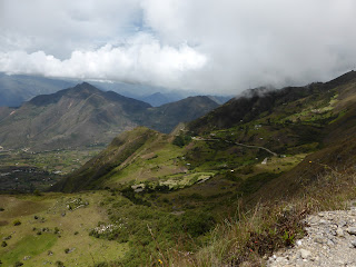
The views along the "detour" were nice


In places spectacular
Soon I reached a better dirt track, but there were no signs of any sort, and I wasn't really sure I was going in the right direction.


I passed a few forks in the road and decided that the more travelled route was probably the principal one, but twice they led me up farm drives, so had to back-track, but than came acros this:
Trench across the road
there were two men digging this trench across the road, completely blocking my progress. I must admit that I had a few seconds of manic laughter, before they rushed off, cut a couple of trees down and constructed a makeshift bridge for me - and also told me I was on the right route! A little further along I saw my first "desvio" - detour - sign, and you can see in the photo that not much traffic had been along this route before me!
Finally came across a detour sign showing the way
As I followed the road the gravel gave way to larger stones, and then mud, and the realisation that had I been in a car or a road bike that I would not have been able to get through this "detour" the police had sent me on. Eventually I came to a larger village, but there were several routes through this, and no signs again, so I stopped and asked and was pointed along one of the roads, which led me to a "main road" - but this main road was dirt, albeit wide and in very good condition. I had no idea where I was, or which way I should turn, as I had been expecting to get back onto the tarmac! Fortunately there were a couple of men sitting on the far side of the road and they called over to me, and indicated I needed to turn right for Celendin - this was, in fact the main road between Cajamarca and Celendin, and the roadworks were part of the resurfacing with tarmac, something not shown on my maps!
The dirt road was in good condition, and I soon reached the start of the tarmac - I had spent about 45 minutes navigating the detour, but it had saved me waiting well over 2 hours at the roadblock, so well worth it. I soon got my first glimpse of Celendin 
Celendin - nestled in the mountains
I needed to make up time, so just paused to fill up my tank and left Celendin behind
The twin-spired church is quite a landmark
and soon got my first glimpses of the Maranon River canyon - deeper that the Grand Canyon in the USA, and my route was taking me right through the middle of it!
First glimpse of the Maranon Canyon with the Maranon river upper centre

My route was going to take me along the side of the canyon ...

... then zig-zagging down to the bottom
Fortunately traffic was very light - I may have seen 20 vehicles the whole day - as the corners were tight, and the road in places very narrow, but I do know that buses ply this route, so was lucky not to come across any. My progress was quite slow, not because of the road conditions - as well as a multitude of hairpin bends there were places where the road surface was badly pitted from previous rockfalls, and landslides - but because of my frequent stops to take photos, as it was so spectacular!

The river valley is very fertile so plenty of agriculture

Part way down looking back - the "lines" are the road I had travelled down tracking back and forth across the mountainside!

Still a long way to go down
At the top it was quite chilly, even though it was a bright sunny day, as I was at over 3000 metres above sea level, but as I dropped down the canyon it got progressively hotter, and I had to remove my warm jacket for something lighter.
An example of one of the many hairpins


Road snaking away into the distance
Between the tight hairpins there were stretches of beautiful road, perfect for biking - long gently curving straights, and even with the knobbly dirt tyres I was enjoying the ride!
Finally got a sight of Balsas, down at the bottom and the Maranon River

A few twists and turns later I was on the banks of the river!
It was almost oppressively hot down at the bottom - the canyon is one of the deepest in the world between 2600 and 3000 metres (8000-10000 feet) deep - so apart from a brief rest to eat a snack bought in a shop, I was ready to continue, also very aware that I still had quite a long ride to Chachapoyas ahead of me. I had now crossed into the Amazonas province.
Climbing the other side of the valley with Balsas in the bottom

... and my route out ahead of me

Balsas - and behind ...

... a close-up of the route I had taken from the top of the photo!

Had to keep stopping to take pictures of the spectacular scenery
As I climbed out of the canyon it was getting much colder, so I had to put a heavier jacket on again.
Oli on the way out of the canyon, showing how narrow the road was in places!
The clouds were also closing in, and rain could be seen sweeping across the canyon
On the way out of the canyon I rode through several light showers, and with the cold it wasn't that pleasant, but kept drying off between the rainshowers.
Part of my route clearly visible below

Almost through the canyon, with Balsas a speck at the bottom
The clouds were getting quite thick now

Here at the highest point on my trip - around 4000 metres (13200 feet) it was also a little misty
I still had around 100 kms to get to Chachapoyas, and was feeling tired, sore and cold - the detour had taken more out of me than I thought. The showers, that I kept riding through, were not that pleasant either, and though my clothing was of the sort that dried quickly, it did mean that I just wanted to get to my destination as quickly as possible. The soreness was caused by the fact that the saddle of the bike is not really designed for touring, being narrow and quite firm, so I was having to make regular stops to stretch my legs - about every 10 minutes by now! Fortunately the road between Leymebamba and Chachapoyas is pretty good, so though it was wet in places it did mean that I could travel at a reasonable speed, and finally arrived in Chachapoyas over 9 hours after I had departed that morning! I vowed never again! Distance travelled was only around 340 kms, so a little over 200 miles, but the detour, and the twists and turns through the canyon had been tiring, though incredibly spectacular. It was one of the hardest days I have spent on a bike, but also, due to the beauty of the countryside I travelled through, one of the best rides of my life!

No comments:

Post a Comment

Please feel free to leave your comments, however Spam or adverts will not be allowed. The blog is open to all so please minimise the use of improper language!